Aerial & Drone Operations
Automated drone dispatch from camera detections, live aerial CV, and multi-sensor fusion.
SeeBlocx integrates fixed cameras and autonomous drones into a single operational loop. When a camera detects an incident, the system can automatically dispatch a drone to the scene for close-up intelligence — fully automated, no operator required.
Capabilities
- Automated drone dispatch from camera event triggers
- Live aerial video analysis with full CV pipeline
- Camera-to-drone handoff — detect wide, inspect close
- GPS-correlated event logging
- Multi-sensor fusion (camera + drone + IoT)
- Thermal imagery overlay & analysis
- Search & rescue support
- Infrastructure inspection from air
Pipeline Blocks Used
What's Inside
Specific capabilities within this domain
Camera → Drone Loop
- Fixed camera detects incident (e.g. congestion, intrusion, accident)
- System automatically initiates drone mission to incident location
- Drone streams live video back to SeeBlocx pipeline
- Aerial feed analysed with same CV blocks as fixed cameras
- Results correlated with original camera detection
- Operator sees unified picture: ground + aerial view
Standalone Aerial Intelligence
- Object detection & tracking on drone feeds
- Vehicle and person detection from altitude
- Thermal / IR overlay for day & night operations
- GPS-tagged detections for mapping & forensics
- Perimeter patrol with automated flight paths
- Infrastructure inspection (power lines, bridges, pipelines)
See It in Action
From pipeline configuration to real-time analytics
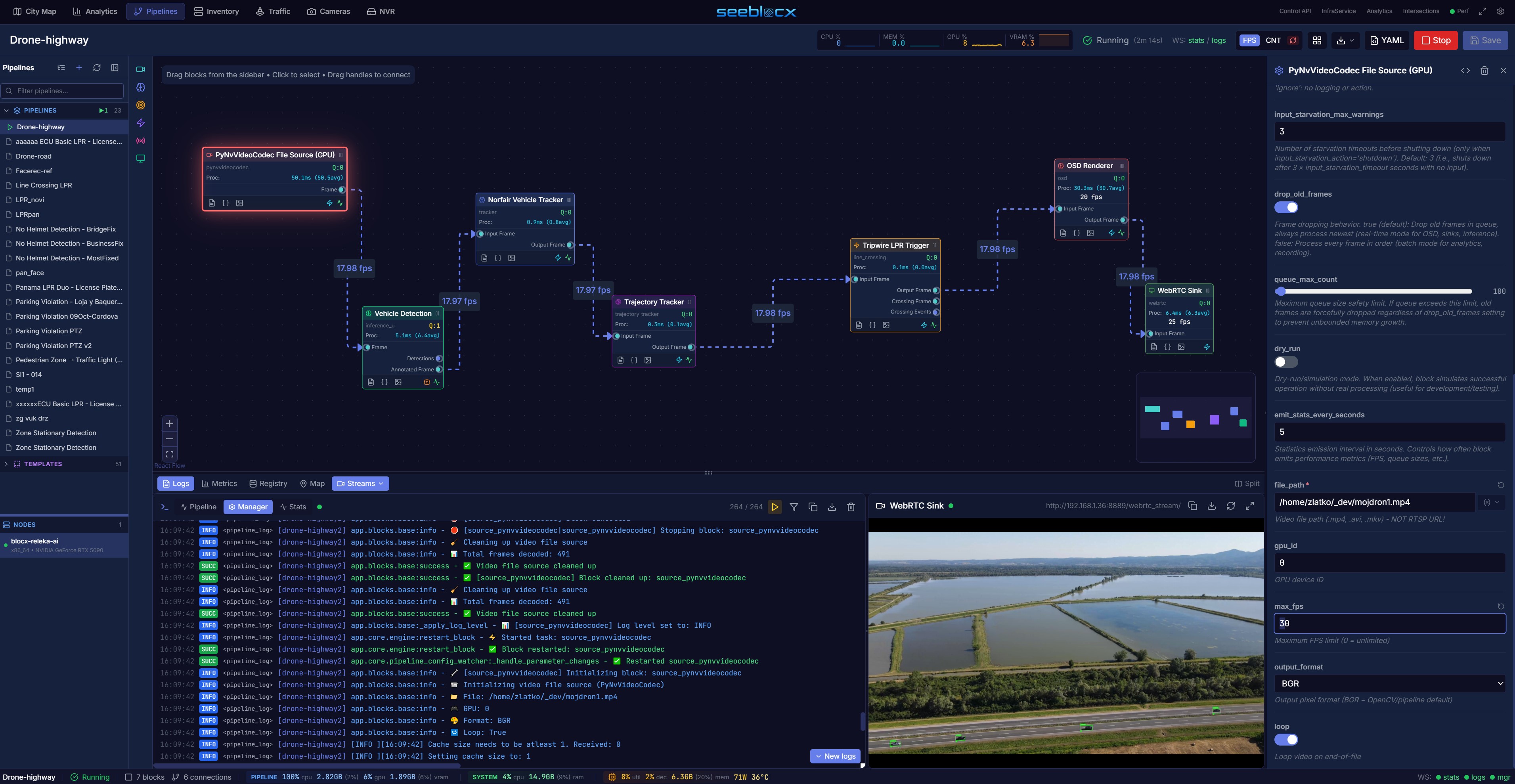
Aerial drone feed with real-time vehicle detection and tracking
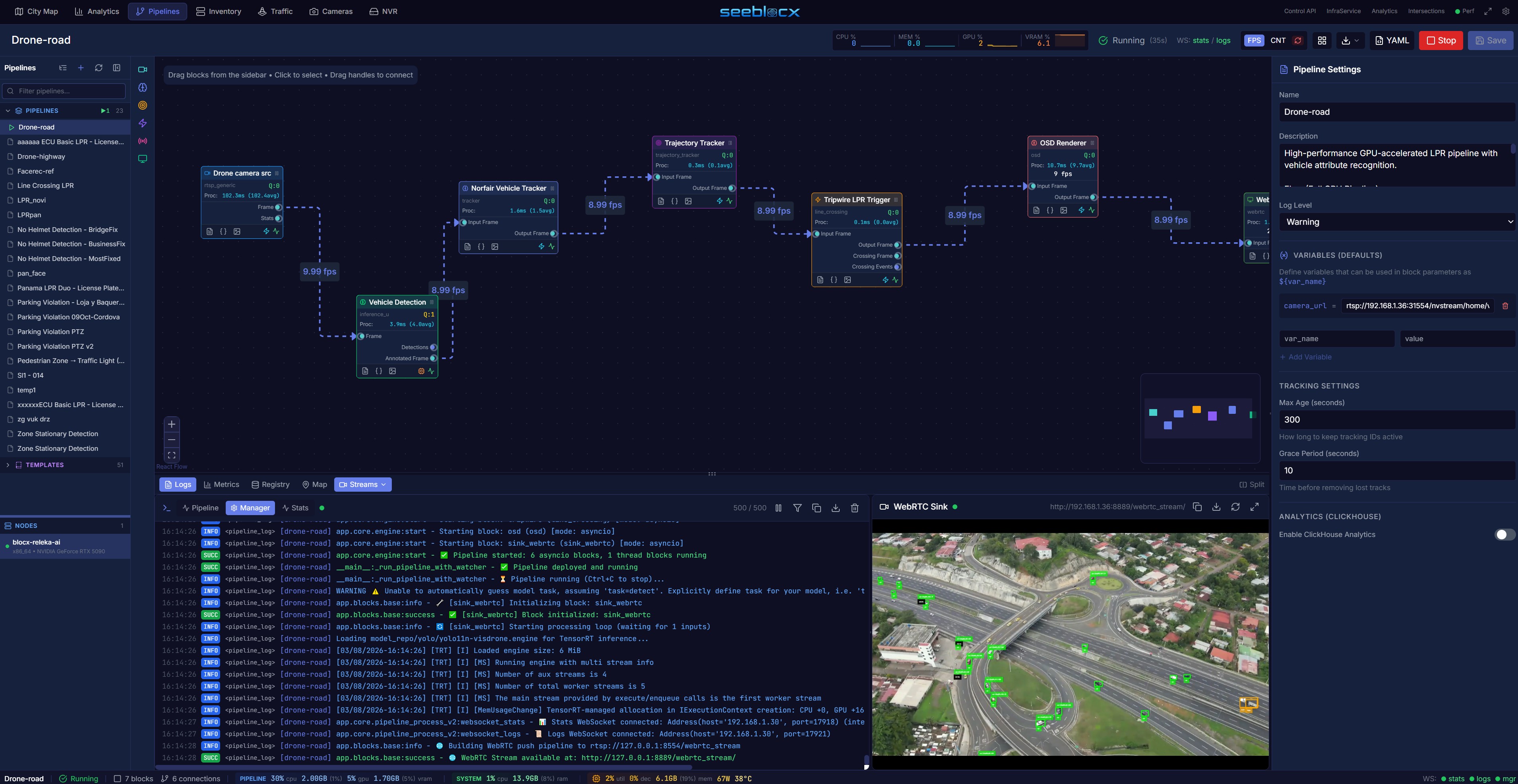
GPS-correlated detections from automated drone dispatch
Drones are a force multiplier for situational awareness — but only when they are part of the operational loop, not a separate tool. SeeBlocx is unique in integrating **fixed camera detection with automated drone dispatch** in a single platform.
The Camera → Drone Loop
When a fixed camera pipeline detects an event — a traffic accident, a perimeter intrusion, unusual congestion — SeeBlocx can automatically trigger a drone mission. The drone flies to the GPS coordinates of the event, streams live video back, and the same CV pipeline blocks (detection, tracking, classification) process the aerial feed. Operators see a unified view: the original wide-angle camera detection plus the drone's close-up perspective. No manual intervention required.
Standalone Aerial CV
Even without the camera trigger, SeeBlocx processes drone feeds (RTSP, RTMP, direct SDK) with full pipeline capabilities. Object detection and tracking work on aerial perspectives. GPS metadata is correlated with every detection for geo-tagged event logs. Thermal/IR overlays support day and night operations.
Multi-Sensor Fusion
SeeBlocx doesn't just process cameras and drones separately — it fuses data across sources. A vehicle detected on a traffic camera can be correlated with the same vehicle spotted from a drone. IoT sensor data (radar, environmental) enriches the picture. This fusion happens at the platform level, not as an afterthought.
Key outcome
Operators get a complete detect-dispatch-inspect-report workflow without switching between systems. The drone becomes an automated extension of the fixed camera network.
Interested in Aerial & Drone Operations?
Contact us to see how SeeBlocx can be configured for your specific aerial & drone operations requirements.
Get in Touch